

Carbon insurance firm Artio, experts in climate risk modelling, has projected significant wildfire exposure areas across four of America’s major national parks over the coming Summer 2026 period, with Sequoia National Park facing the highest proportional risk of the parks assessed.
Using historical satellite fire data (MODIS) alongside key climate variables, including temperature, relative humidity, wind speed, and 24-hour precipitation. Artio’s modelling projects areas at risk of burning between now and the end of August 2026. Fire spread is simulated using a cellular automata model, which maps how fires can propagate across different terrains and vegetation types. When set against recent conditions, the analysis indicates that for three of the four parks assessed, projected exposure for April–August 2026 sits above the average observed over the same period in the previous five years, suggesting an elevated baseline of risk heading into the peak fire season. This comes amid climatic conditions that may support greater fire risk in some regions over the coming months.
Crucially, these projections are evaluated across multiple Shared Socioeconomic Pathways (SSPs). SSPs are globally recognised climate scenarios that combine assumptions about population growth, economic development, energy use, policy decisions, and emissions to model alternative future climates. This approach allows Artio to capture a range of potential climate outcomes rather than relying on a single projection.
Based on these models, the following U.S. National Parks are predicted to be impacted:
| Park | Projected Burnt Area (% of park) | Area at risk (km²) |
| Sequoia | 1.74% | 28.65 (approx. 7,080 acres) |
| Yosemite | 1.08% | 46.98 (approx. 11,610 acres) |
| Kings Canyon | 1.04% | 43.80 (approx. 10,822 acres) |
| Smoky Mountains | 0.46% | 12.79 (approx. 3,160 acres) |
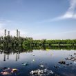
While the percentages may appear modest in isolation, the absolute scale of land at risk is significant, particularly given the ecological importance of these landscapes. Yosemite, Sequoia and Kings Canyon are home to some of the oldest and most ecologically important forest systems in the world, including mature old-growth trees with immense biodiversity value and carbon stocks accumulated over centuries. These ecosystems can take decades or longer to recover after severe fire events.
The 2026 wildfire outlook is concerning when comparing the April–August forecast against the five-year historical average. Yosemite is the only site forecast to sit below its recent baseline, while Sequoia shows a moderate increase. Kings Canyon and the Great Smoky Mountains stand out most, with forecast exposure significantly above historical levels, indicating a materially elevated risk in both areas.
| Location | Historical Average | Forecast |
| Yosemite | 1.56% | 1.08% |
| Sequoia | 1.43% | 1.74% |
| Kings Canyon | 0.34% | 1.04% |
| Great Smoky Mountains | 0.04% | 0.46% |
The conditions of this years’ peak wildfire season (June through October) also bring concern. In California in particular, there has been very low snowpack and early snowmelt this year which could contribute to earlier drying of fuels and a more fire-conducive environment. As of April 1, 2026, California’s Sierra Nevada snowpack has collapsed to 18% of the average for that date, making it the second lowest on record, following an extraordinarily hot and dry March. Climate in the region this year is also expected to be influenced by the potential emergence of El Niño conditions, which are associated with heightened weather variability and increased wildfire risk.
Bilal Hussain, CEO and Co-founder, Artio comments: “Wildfire risk is becoming increasingly easy to predict, driven by more precise tree species mapping and AI-enabled analysis. This kind of modelling allows us to move beyond broad warnings and pinpoint where fires are most likely to take hold, turning climate risk into something that can be clearly understood and managed.”
As climate variability intensifies, the threat to national parks needs to be addressed. Through measurable and geographically at-risk signals, stakeholders have a window to deploy preventative measures before damage occurs.”
- Artio
-