










Google, in collaboration with the Leverhulme Centre for Nature Recovery at the University of Oxford, has released a high-resolution, vectorized dataset mapping millions of fine-scale ecological features across the British countryside.
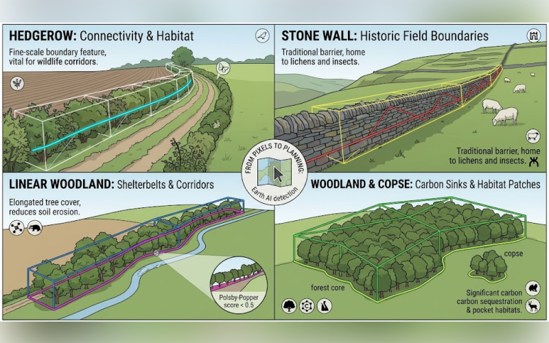
Utilising a proprietary deep learning framework, the open-access inventory explicitly identifies small-scale landscape elements such as hedgerows, stone walls, and isolated copses.
Historically, these micro-habitats have remained undetected by national forest inventories due to the spatial limitations of standard orbital tracking, which tends to favour large, contiguous woodlands.
The release marks a significant transition from Google’s previous Farmscapes 2020 project, which originally mapped overlooked woodlands across England using pixel-based raster models.
This new vector format converts those digital pixels into precise, actionable geometries, allowing land managers, conservationists, and policymakers to accurately measure, track, and expand small-scale carbon-sinking features without displacing active agricultural production or compromising food security.
Mapping the intricate patchwork of working agricultural lands presents severe engineering challenges at the intersection of spatial topology, semantics, and computational scale.
In rural landscapes, ecological features frequently overlap—such as a managed hedgerow growing directly atop a traditional stone wall—confounding conventional single-layer mapping models.
Furthermore, processing a high-resolution territory map of England, which spans over 130,000 square kilometres, requires dividing the area into a grid of independent digital tiles. This partitioning process historically resulted in geographical features being artificially sliced at the tile boundaries.
To resolve these topological and scaling constraints, Google developed a specialized pipeline using Google Earth Engine.
The system deploys dual-layer labelling by pairing sub-meter satellite imagery with 1-meter LiDAR elevation data, allowing the neural network to differentiate ground-level boundaries from above-ground canopies occupying the exact same coordinates.
A scalable stitching algorithm was then engineered to dynamically recombine fragmented geometries across tile borders, whilst parallel cloud processing allowed the platform to bypass traditional processing bottlenecks and generate millions of distinct polygon geometries concurrently.
To transform these raw digital outlines into a semantically useful ecological inventory, Google had to train the system to understand contextual classification.
While artificial intelligence can easily detect raw vegetation, it cannot inherently distinguish between a commercial orchard, a continuous forest edge, or a wildlife corridor.
The system addresses this by evaluating the physical footprint of each detection using a mathematical metric known as the Polsby–Popper compactness score, which calculates the ratio of an object’s area to the square of its perimeter.
Through this geometric intelligence, the model defines standard woodlands as contiguous canopies with a minimum diameter of 30 metres, whilst classifying small isolated copses or scrub clusters as woody patches.
Linear features, such as elongated corridors and hedgerows, are strictly isolated by a compactness score of less than 0.5, allowing the system to programmatically identify the long, thin corridors that are structurally vital for wildlife migration across fragmented landscapes.
Due to the scarcity of highly specific countryside training sets, Google trained its network using a Remote Sensing Foundations Vision-Transformer backbone.
Part of the Google Earth AI suite, this foundational model was pre-trained on more than 300 million global satellite images, providing the core system with an advanced baseline understanding of environmental textures and shapes before it was fine-tuned on the British landscape.
Looking forward, Google is investigating how this high-precision tracking framework can be applied to diverse nature-based solutions, particularly in quantifying fine-scale biomass within active silvopasture and agrisilviculture systems.
Additionally, researchers intend to use the tracking pipeline to identify localized carbon leakage events, ensuring that regional conservation gains are not inadvertently offset by environmental degradation occurring just beyond a project’s boundaries, thereby offering a critical pathway to scale restoration across working lands.